The Canterbury Nor'wester
New Zealand is well known for its beautiful diversity of landscape. The South Island especially has unique weather patterns from its diverse physical geography. An excellent example of this is the Southern Alps influence on the Canterbury Plains located on the southeast side of New Zealand’s South Island. Here one can witness one of the most dramatic weather patterns in the world - the Canterbury Nor’westerly, which usually takes place in the spring (Mullan, Tait, and Thompson). The Canterbury Nor’westerly is a wind pattern caused by prevailing westerly surface winds that carry low pressure winds eastward to the South Island; depressions (systems of low atmospheric pressure) develop in these winds as they travel east (Metservice). The westerlies also contain a lot of moisture; as they hit the Southern Alps on the South Island, they rise and cause a rainshadow effect that drops the majority of moisture on the western slope of the Alps but continue over the mountains to the eastward Canterbury Plains with little moisture. (This is also known as a foehn wind.)
Adiabatic cooling and heating processes compress the air as it descends down the eastern side of the Alps, causing extremely hot, dry winds to rush down the river valleys of the Rakaia, Rangitata, and Waimakariri rivers (Relph).
The valleys funnel the wind onto the Canterbury plains with a great amount of force which can last for up to 5 days (Relph). The Canterbury Nor'wester is usually preceded by an arch of clouds that appear over the Southern Alps as a visible representation of the leftover moisture from the rainshadow effect that is then condensed into a band of clouds before it evaporates moves down the eastern mountainside. The Nor’wester has also been blamed for an increase in rates of suicide and domestic violence as it has been known to cause great destruction.
.
Adiabatic cooling and heating processes compress the air as it descends down the eastern side of the Alps, causing extremely hot, dry winds to rush down the river valleys of the Rakaia, Rangitata, and Waimakariri rivers (Relph). The valleys funnel the wind onto the Canterbury plains with a great amount of force which can last for up to 5 days (Relph). The Canterbury Nor'wester is usually preceded by an arch of clouds that appear over the Southern Alps as a visible representation of the leftover moisture from the rainshadow effect that is then condensed into a band of clouds before it evaporates moves down the eastern mountainside. The Nor’wester has also been blamed for an increase in rates of suicide and domestic violence as it has been known to cause great destruction (Relph).
.
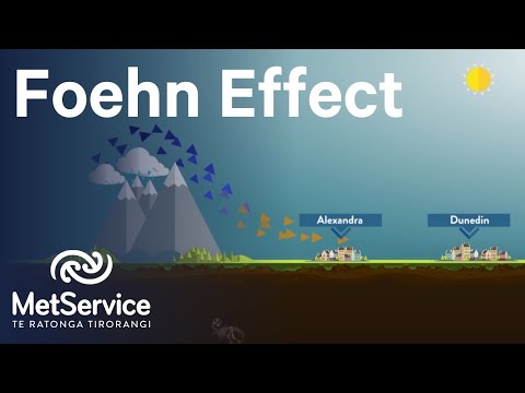 |
| Figure 1: The windward side of the Alps (where the city of Otago is located) receives all the moisture while the leeward side drier (Metservice) |
 |
| Figure 2: Waiatoto River valley, through which the Nor'wester is funneled out to the Canterbury Plains (McCarthy) |
The valleys funnel the wind onto the Canterbury plains with a great amount of force which can last for up to 5 days (Relph). The Canterbury Nor'wester is usually preceded by an arch of clouds that appear over the Southern Alps as a visible representation of the leftover moisture from the rainshadow effect that is then condensed into a band of clouds before it evaporates moves down the eastern mountainside. The Nor’wester has also been blamed for an increase in rates of suicide and domestic violence as it has been known to cause great destruction.
.
 |
| Figure 2: The Canterbury Arch over the Southern Alps, caused by the condensation of remaining moisture from the foehn wind at the top of the "wave" of air flowing upward from the westerlies hitting the western slope. (Groves) |
.
References
Relph, David. "The Canterbury Nor’wester." New Zealand Geographic. New Zealand Gographic, n.d. Web. 1 Mar. 2017.
Brenstrum, Erick. "Canterbury’s Damaging Nor’wester." New Zealand Geographic. Kohnwai Media, n.d. Web. 05 Mar. 2017.
"New Zealand Climate." Met Service. Meteorological Service of New Zealand Ltd., n.d. Web. 2 Mar. 2017.
Brett Mullan, Andrew Tait and Craig Thompson, 'Climate', Te Ara - the Encyclopedia of New Zealand, 12 June 2006. Web. 5 March 2017.
"New Zealand Climate." Met Service. Meteorological Service of New Zealand Ltd., n.d. Web. 2 Mar. 2017.
Macara, G.R. "Canterbury." NIWA. NIWA Taihoro Nukurangi, n.d. Web. 1 Mar. 2017.
Allen, Casey. "Earth's Circulation Schemes." Intro to Physical Geography. University of Colorado Denver. Spring 2017.
Photo References
Figure 1: Still from "How the Foehn Wind Affects New Zealand's South Island." Metservice NZ. 14 Feb. 2015. Web. 05 Mar. 2017.
Figure 2: McCarthy, Forrest. "South Island, New Zealand." Forrest McCarthy. Blogspot, 2 Feb. 2013. Web. 05 Mar. 2017.
Figure 3: Groves, Nick. "The Canterbury Nor'wester." New Zealand Geographic. New Zealand Geographic. n.d.Web. 5, Mar. 2017.


Comments
Post a Comment